All 11 terrain models — footprint, scale, altitude range, and downloadable KML files for Géoportail and Google Earth.
| # | Site | Massif / Range | Footprint | Scale | Print size | Alt. min (z_base) | Alt. max | KML | Page |
|---|---|---|---|---|---|---|---|---|---|
| 01 | Dent du Géant | Mont-Blanc Massif | 2 × 2 km | 1 : 8,000 | 250 × 250 mm | 2,751 m | 4,013 m | ↓ KML | Explore → |
| 02 | Aiguille d'Argentière | Mont-Blanc Massif | 2 × 2 km | 1 : 8,000 | 250 × 250 mm | 2,757 m | 3,894 m | ↓ KML | Explore → |
| 03 | Aiguille de Bionassay | Mont-Blanc Massif | 2 × 2 km | 1 : 8,000 | 250 × 250 mm | 2,730 m | 4,042 m | ↓ KML | Explore → |
| 04 | Aiguille du Midi | Mont-Blanc Massif | 2 × 2 km | 1 : 8,000 | 250 × 250 mm | 2,406 m | 3,841 m | ↓ KML | Explore → |
| 05 | Mer de Glace | Mont-Blanc Massif | 2 × 4 km | 1 : 8,000 | 250 × 500 mm | 1,230 m | 2,677 m | ↓ KML | Explore → |
| 06 | Aiguille Verte | Mont-Blanc Massif | 2 × 2 km | 1 : 8,000 | 250 × 250 mm | 2,822 m | 4,116 m | ↓ KML | Explore → |
| 07 | Vallée de Chamonix | Mont-Blanc Massif | 14 × 14 km | 1 : 60,000 | 233 × 233 mm | 975 m | 4,097 m | ↓ KML | Explore → |
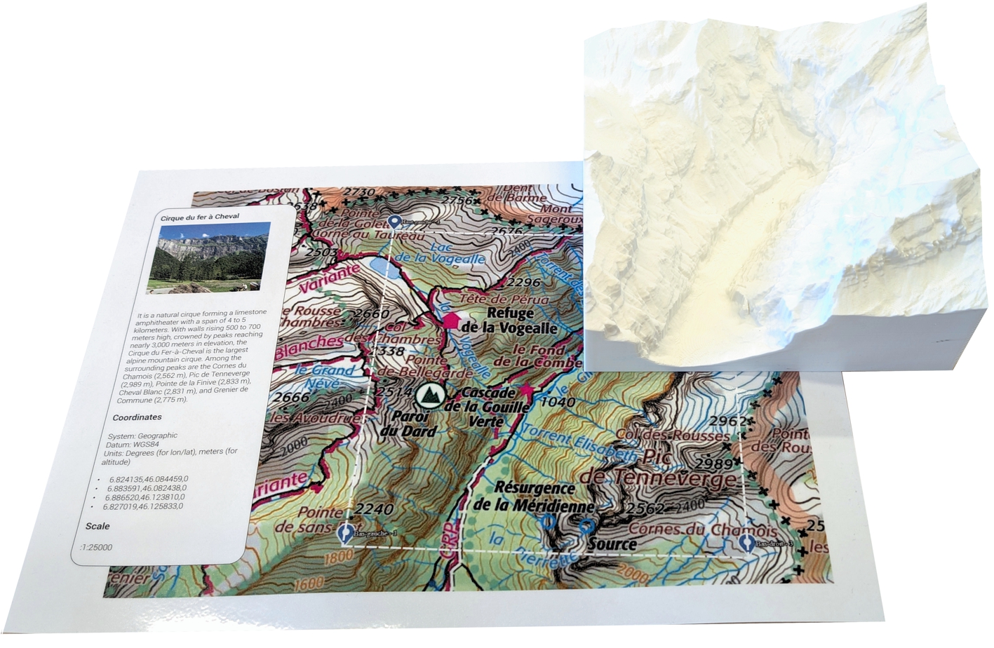
| 08 | Cirque du Fer à Cheval | Préalpes du Giffre | 6 × 6 km | 1 : 24,000 | 250 × 250 mm | 862 m | 3,020 m | ↓ KML | Explore → |
| 09 | Cirque de Gavarnie | Pyrenees | 5 × 5 km | 1 : 20,000 | 250 × 250 mm | 1,370 m | 3,249 m | ↓ KML | Explore → |
| 10 | Pic du Midi d'Ossau | Pyrenees | 3 × 3 km | 1 : 12,000 | 250 × 250 mm | 1,537 m | 2,887 m | ↓ KML | Explore → |
| 11 | Vallée des Glaciers | Mont-Blanc Massif | 6 × 6 km | 1 : 24,000 | 250 × 250 mm | 1,639 m | 3,020 m | ↓ KML | Explore → |
Alt. min = z_base (model base slice) · Alt. max = highest terrain point in model · Scale = horizontal & vertical (Z × 1.0, no exaggeration) · Projection: Lambert-93 / RGF93v1
Cartes IGN — Français
Cartes topographiques IGN imprimables pour les 11 sites, à l'échelle du modèle 3D correspondant.
↓ Télécharger (PDF)IGN Maps — English
Printable IGN topographic maps for all 11 sites, scaled to match the corresponding 3D model.
↓ Download (PDF)Based on a LiDAR-derived Digital Elevation Model (DEM), each site is processed into a 3D-printed topographic model. Each model is complemented by printed IGN topographic maps, precisely matching the represented area. Together, they form a teaching tool for geography educators, helping students understand terrain, map reading, and the relationship between 2D cartographic representations and real-world 3D landforms.
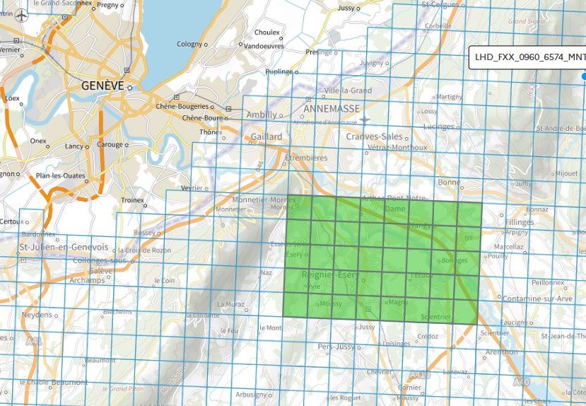
DEM Download — Géoservice IGN
A DEM (Digital Elevation Model) is a digital representation of the ground surface, showing the terrain's elevations. LiDAR HD provides high-resolution 3D measurements of the land using laser scanning from planes or drones. The LiDAR HD derived products download interface allows users to select areas and download DEMs, DSMs, and other terrain data for analysis or 3D modelling.
→ LIDAR HD – Download interface (Géoservice IGN)
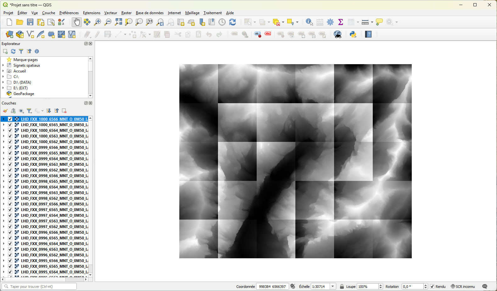
QGIS — Raster Processing
QGIS is a free and open-source Geographic Information System (GIS) software. It allows users to visualise, analyse, and manage spatial data such as maps, satellite images, and LiDAR models. QGIS is widely used for cartography, spatial analysis, and creating custom geographic tools.
- Add the relevant rasters as layers
- Merge rasters into a single DEM
- 3D export using the DEMto3D plugin
3D Export — DEMto3D Plugin
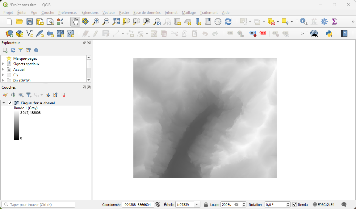
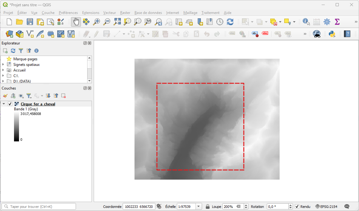
Export is performed using the DEMto3D plugin with precise coordinate bounds in Lambert-93 / RGF93 projection. The example below shows the coordinates used for the Cirque du Fer-à-Cheval case study:
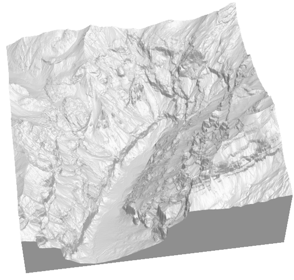
3D Printing & Pedagogical Assembly
The exported STL file is sent to a 3D printer (FabLab). The printed model is matched with a printed IGN topographic map at the same scale, forming a complete pedagogical tool for the classroom. The GLB file is used for the interactive 3D viewer on this website.
Source files for the Cirque du Fer-à-Cheval case study. The QGIS export parameters (XML) can be adapted for any other site. Full process documentation: nationsdesign.online/geo3d.
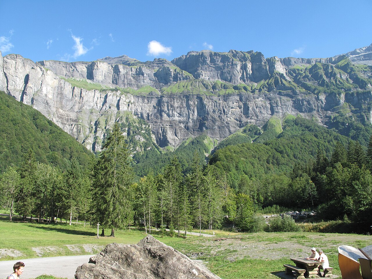
Geography. A natural cirque forming a limestone semicircle 4 to 5 kilometres in extent. With cliffs 500 to 700 metres high, crowned by peaks approaching 3,000 metres, the Cirque du Fer-à-Cheval is the largest mountain cirque in the Alps. Surrounding peaks include the Cornes du Chamois (2,562 m), Pic de Tenneverge (2,989 m), Pointe de la Finive (2,833 m), Cheval Blanc (2,831 m), and Grenier de Commune (2,775 m).
Geology. Jurassic limestones, highly fractured. Heavy rainfall accelerates erosion and has caused numerous landslides throughout history — the most famous in 1602 buried several hamlets. In 2003, 300,000 m³ collapsed near the Nant des Pères stream. On September 6, 2025, approximately 35,000 m³ fell at Pas Noir near the Cascade de la Méridienne.